
 Recently I came across some videos online showing some great-looking trails in the Loanhead / Bilston area. We decided to go there and try some of them out, but we would strongly advise anyone NOT to follow our route to the letter; all will become clear further down…
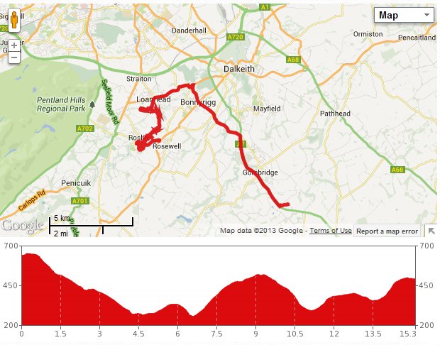
First thing was getting to Loanhead, so we chose the most direct route, down the A7, across to Bonnyrigg, down through Lasswade and up to Loanhead. Just past the LO-GY centre there is an access point to a cycle path that uses the old railway line joining Loanhead and Roslin. We got there in just over 40 minutes, then joined the path, looking for a little off-road fun.
Almost immediately, the land on the right opened up into a wide clearing: the site of former industrial workings. There were lots of paths leading away from the course of the old railway and through that clearing, so we left the paved cycle track behind and went off exploring. We were drawn to one path running through woods, and followed it for a few minutes, until we spotted a nice narrow track heading uphill and alongside a ploughed field. This was a fun little twisty path to follow, which we did until it ran between some very sharp thorn bushes. Just before this point we paused and noticed a massive bramble patch. This patch was in full sunlight and full of ripe brambles (in contrast to many of the other bushes we have seen recently, which are still at least a week or two behind). We filled a tub to the brim with the juicy berries before getting back on our bikes and retracing our steps back to the cycle path.

Bilston Viaduct
We now carried on over the Bilston viaduct: a very substantial white-painted iron structure traversing a surprisingly deep gorge. As soon as we crossed, we took a left turn into woods again, following a signpost for Polton. This was a pleasant and fairly easy-going ride. Pretty soon we stopped to look at an information board on our right. Through a gate, this was next to a narrow path leading to Hewan Bank. We vaguely remembered walking this path a good few years ago, so we decided to follow it on our bikes. This was our big mistake!
We got as far as the steps leading down. I thought if this is a dead end, I don’t want to be carrying my bike all the way back up those steps. We headed back for a moment, then looked at the map provided by the sign. It showed paths leading on to Roslin and Polton from the bottom, so we decided to risk it after all.
After carrying our bikes down, we reached the River North Esk. We broke out the flask and sipped tea while contemplating the information imparted by yet another information board, which explained that this was the site of a bloody battle in 1303, where countless Englishmen met their gory fate in the river. The modern name for this place (Hewan) comes from “The Hewing”, which the area was called after the battle. It made me shiver thinking about it.
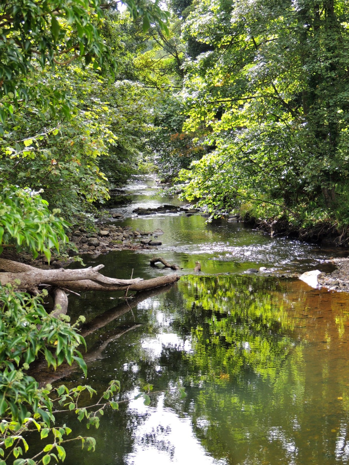
River North Esk looking tranquil
We could only see one obvious way forward from this place, which was up-river. So we carried on in that direction, although the path was very narrow and tricky in places. Pretty soon, the obstacles got more difficult, and we were off our bikes more than on them. I guess we could have taken the hint at that point, but we kept going, in the hope that the path would soon widen out into something more respectable.
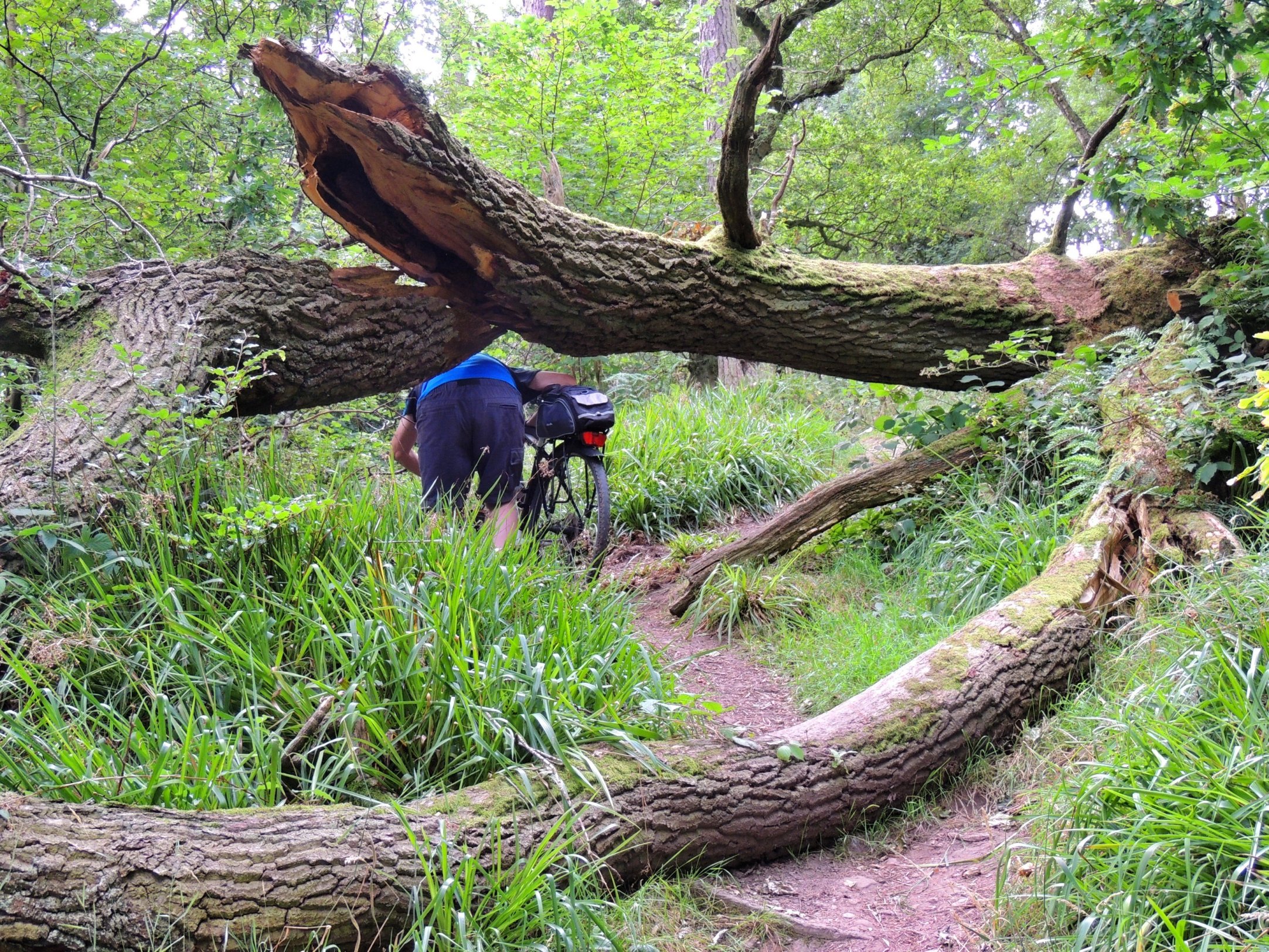
It was more obstacle course than cycle path
Fallen trees were all over the place – some of them pretty massive and needing teamwork to get the bikes one-by-one over or under the obstacles. The opportunities to get onto the bike even for 20 or 30 yards at a time became fewer and fewer. At one flattish section I took my chance and started cycling along the narrow path. But the ground under my rear wheel gave way, causing me to fall off to my right, into some very soft undergrowth. Colette caught me up and we both had a laugh. I got back on, then promptly lost my balance again, falling against a fence on my left. The fencepost was rotten and gave way, spilling me off to the left this time. I just lay there and laughed – what on earth was I doing here with a bike!
We carried on regardless, and as we progressed further, the path went right down to the riverside, which meant we had the additional problem of areas of erosion. The path got down to a foot wide in some sections, which would be bad enough for a normal walk, but pushing a bike, it got quite scary. On the final section alongside the river, we had to negotiate a narrow rock ledge running alongside a rock wall, like a miniature Andean pass but with slighlty less of a drop! At the narrowest point, some kind soul had installed a metal grab rail, which gave us a little bit of security.
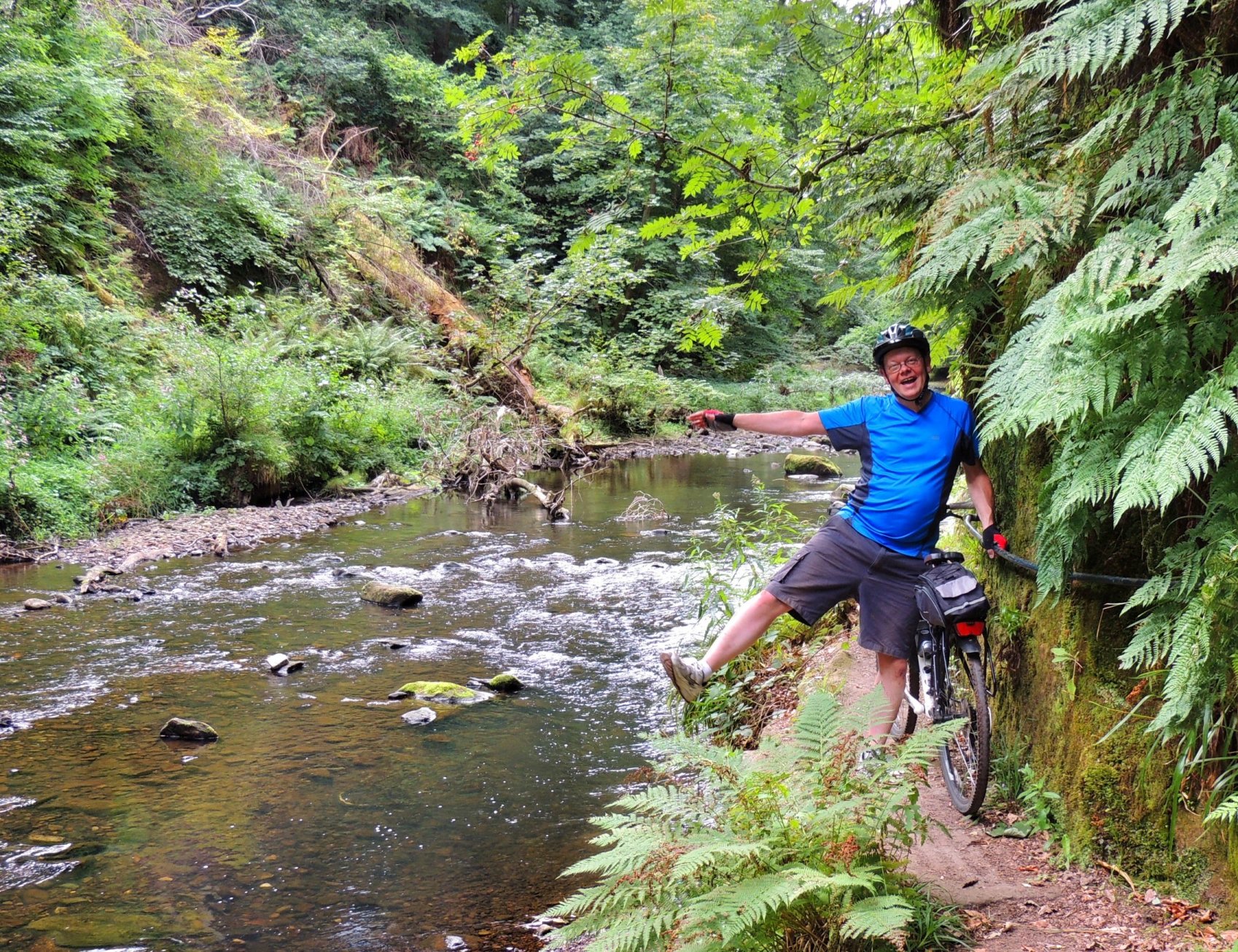
I found a handrail and tested to make sure it was secure
Then along came a couple of guys, who seemed quite surprised to see us lugging bikes along the path. We explained our predicament. They though we might be best retracing our steps, but that wasn’t what I wanted to hear! However, they told us that if we carried on, the worst of the riverside rock scrambling was just about over.
That was true, but we still needed to lug our bikes up stepped rocks as the path rose steeply from the riverside. The sweat was pouring off me by the time we’d got to the top of the path. The guys had told us to take the left turn at this point, which we did, and wearily walked our bikes down the slope to the next obstacle.
An eager springer spaniel caught up with us there, quickly followed by his owner, who very helpfully explained how to get out of the woods. We let her go in front and followed on, only to catch her up again as she was explaining the path to some German tourists. Front then on, she led us through the woods towards civilisation and being a local from Roslin, she was able to tell us some interesting facts about the locale at the same time. The path took us to the foot of Roslin Castle, then finally across a footbridge and into Roslin Glen country park. We thanked the lady very much and took a well earned rest on a bench.
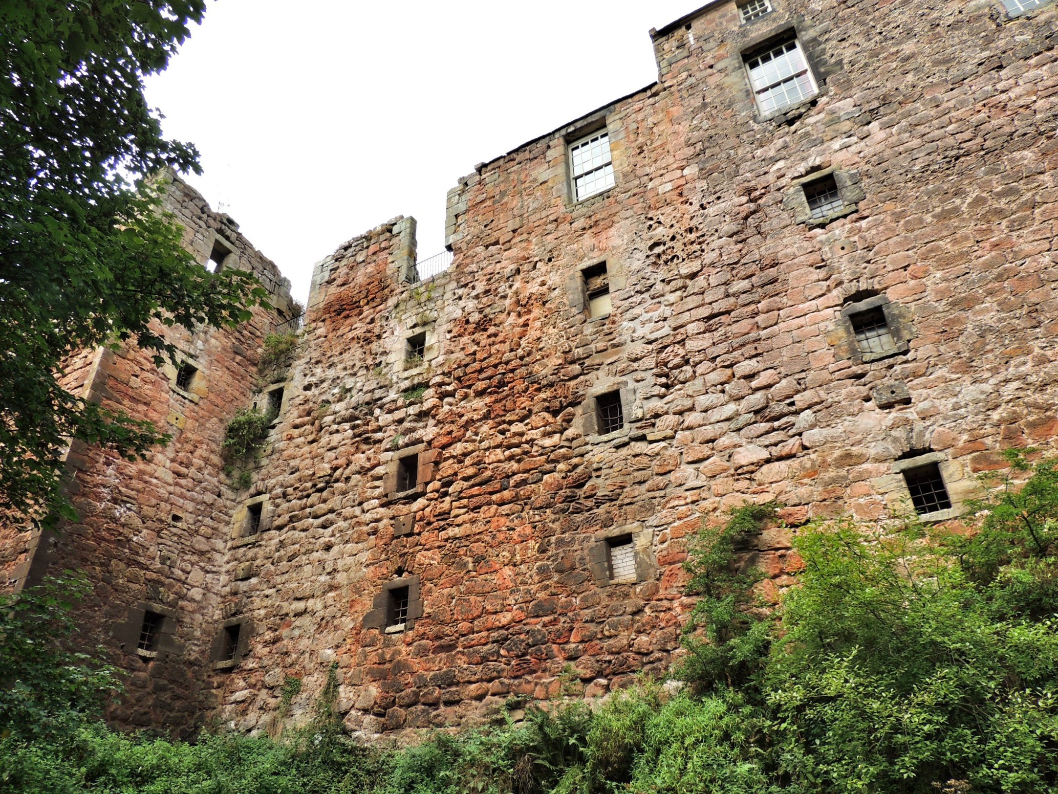
Roslin Castle
There was now the small task of getting ourselves home, but being exhausted after spending over two hours lugging our bikes through inappropriate terrain, we called our daughter Lucy to come and rescue us. Unfortunately, there was no signal at the bottom of the glen, so we rode up to the car park at the south end of the glen road. In doing so, we passed the site of a recent accident where a cyclist was killed. Very sad.
Once at the car park, Colette tried phoning again and was successful this time; Lucy was happy to drive the car to get us. While we iwaited, we got a good view from there over to Roslin Chapel on the other side of the glen, with all the scaffolding recently removed. Soon Lucy arrived, the bikes were secured and we were driving home. We had only done 15 miles at an average speed of 4mph, but we were done in!