
 Poring over maps of the local roads, I found another track that looked very interesting, running through the Moorfoot hills near Fountainhall. It did look a little steep in places, but no problem – we could always turn back if it got too hard.
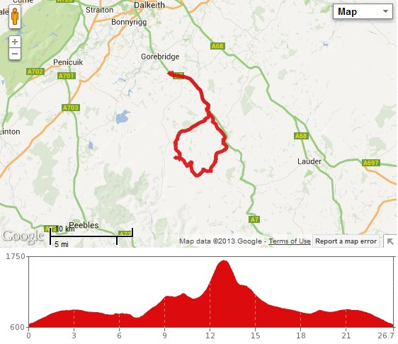
So on a lovely calm, sunny day, we set off heading south up the A7 after leaving North Middleton. We climbed steadily for a few miles, then picked up more speed as the road leveled off a bit after leaving Midlothian and entering the Scottish Borders. Around about this point, I was spotted by a herd of bullocks in the field to my left, one of whom decided to make a race of it. Soon all 50-odd were thundering alongside me, like something out of a cowboy movie. It was so exhilirating, I couldn’t resist shouting “yee-ha!”. The field seemed to go on for quite a distance, but sadly the fun was brought to an end by the fence, and soon we were leaving the cows behind and turning away from the A7 into Heriot.
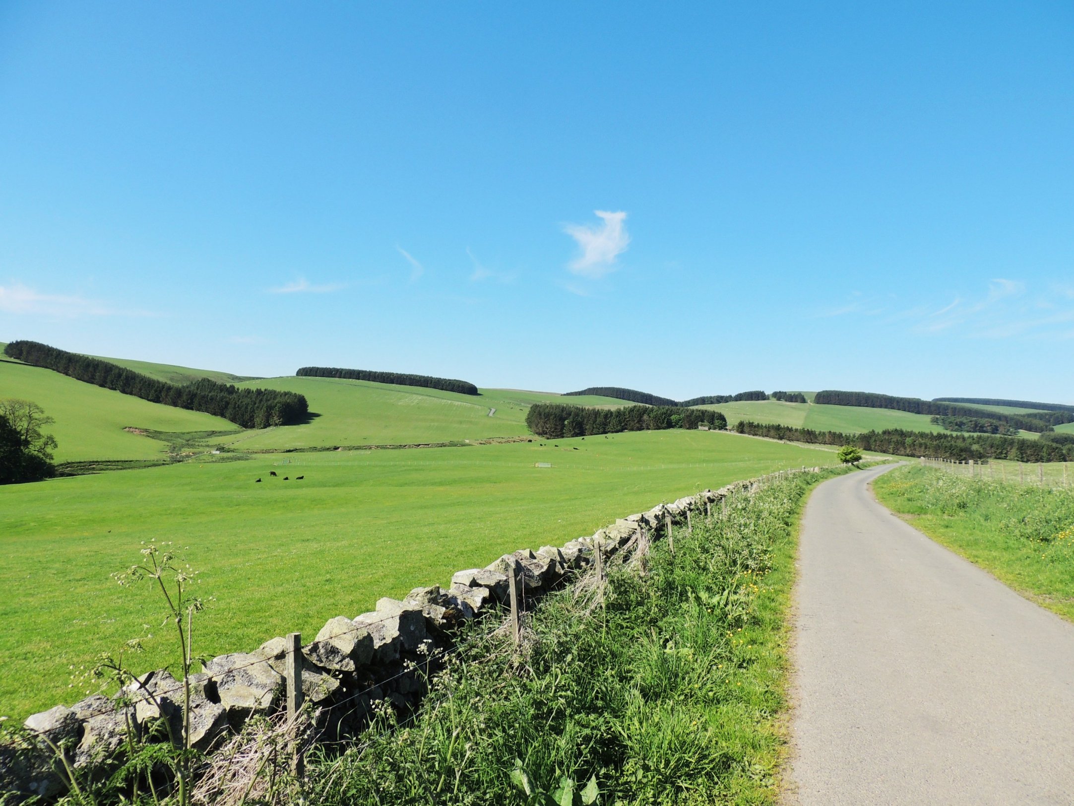
Shortly after passing through Heriot, we took a left signposted for Fountainhall. This part of the road is quite up and down, in contrast to the A7 and the Borders Railway line, which run parallel on the left, taking a more level path. After a pleasant few miles, we arrived at a junction marked “Pirntaton” and turned right. From this point, the theme of uphill and more uphill began. It was gentle enough at first, so we could wave and smile sweetly to the occupants of one of the houses we passed, out enjoying the warm sunshine. But the gradient got harder as we progressed and became a bit of a slog. After we reached a cattle grid, the road surface changed from tarmac to farm track, albeit a fairly good one, and the scenery changed from farmland to moorland. We took the right fork there towards Over Shiels farm, where the track takes an abrupt right turn then heads mercilessly uphill. It was a slog getting up, and so we took a well-earned break in front of the gate at the top of the climb.
A lovely day for a bike ride!
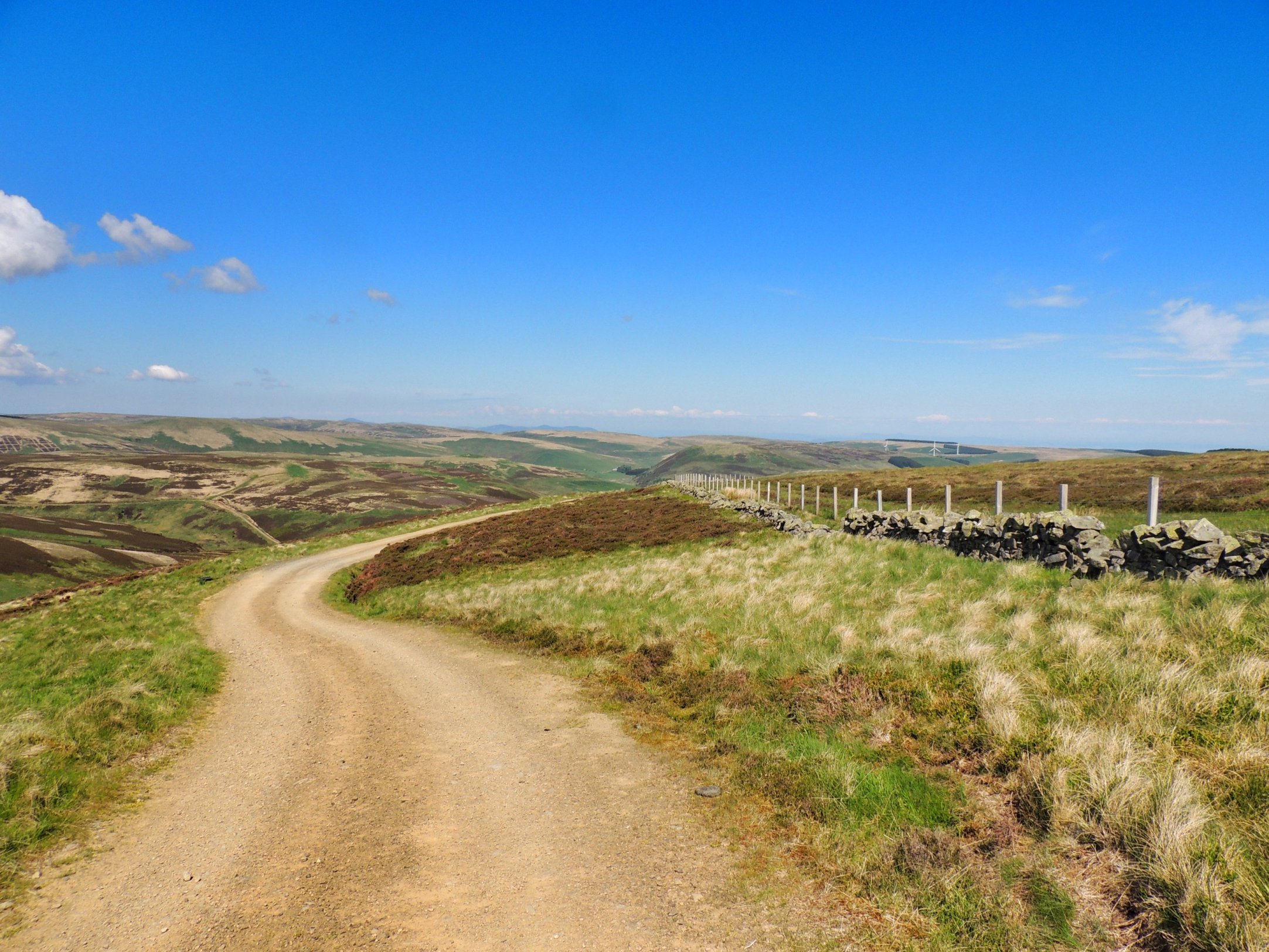
The sign on the gate said “Private road” but all that means now is no cars – freedom to roam made us confident enough to open the gate and venture onwards by bike. The outlook from this point was stunning and gave a good view of the track winding its way around the hillside.
Don’t stop pedalling or you’ll get wet!
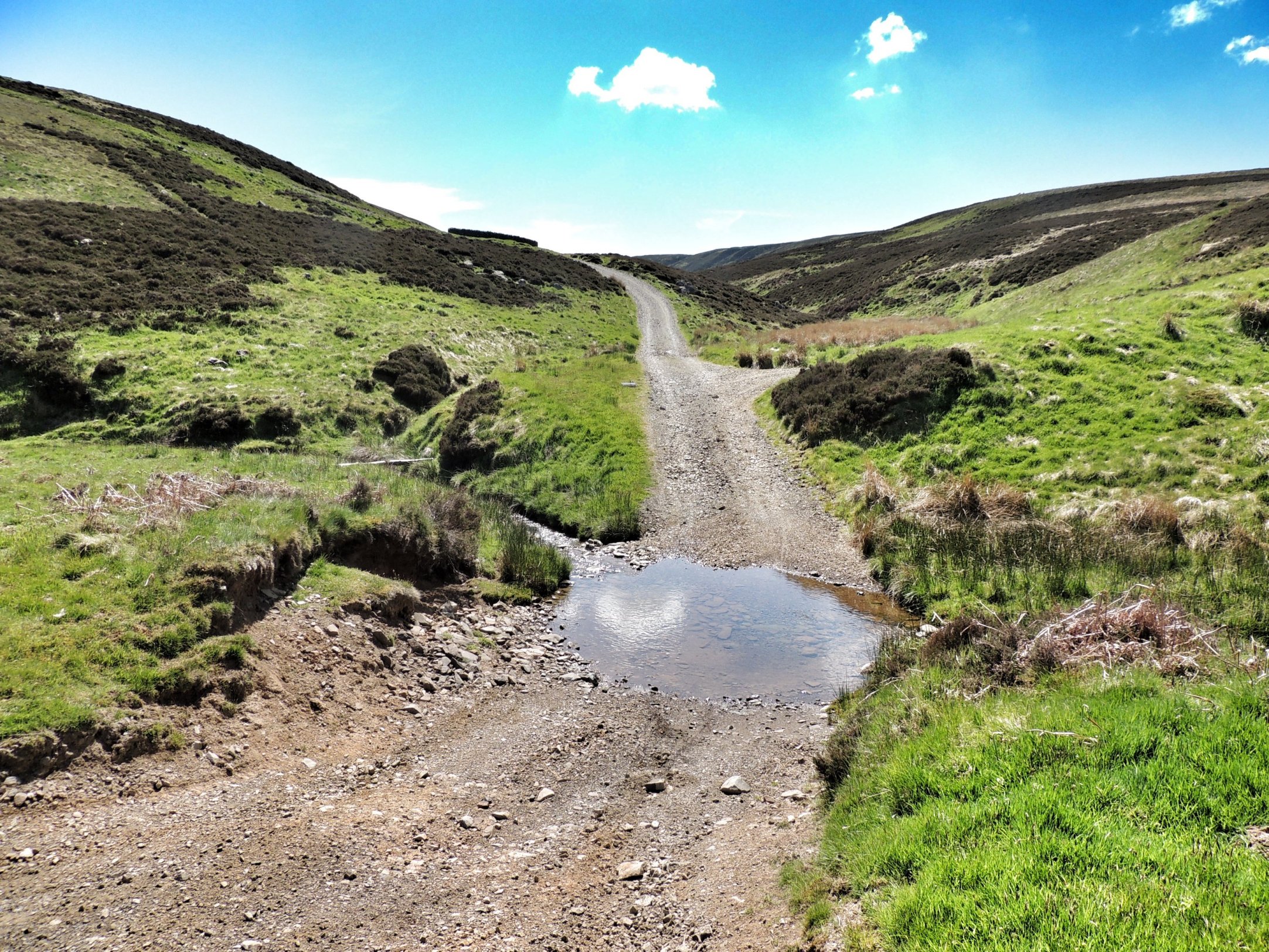
A ford lay in wait for us at the bottom of the first downhill, which I promptly got stuck in, soaking my trainers! Remember to change down gear BEFORE entering a ford in future… Colette sailed through unscathed.
As we continued along the track, the view was constantly changing and more of the road ahead could be seen. At some points it looked really daunting, but we managed to ride up most of it, taking a few breaks for breath. However, it all got too much for us after we passed the turning for Trously and hit the really steep section heading up towards George Wood – I don’t mind admitting that we pushed the bikes up that.
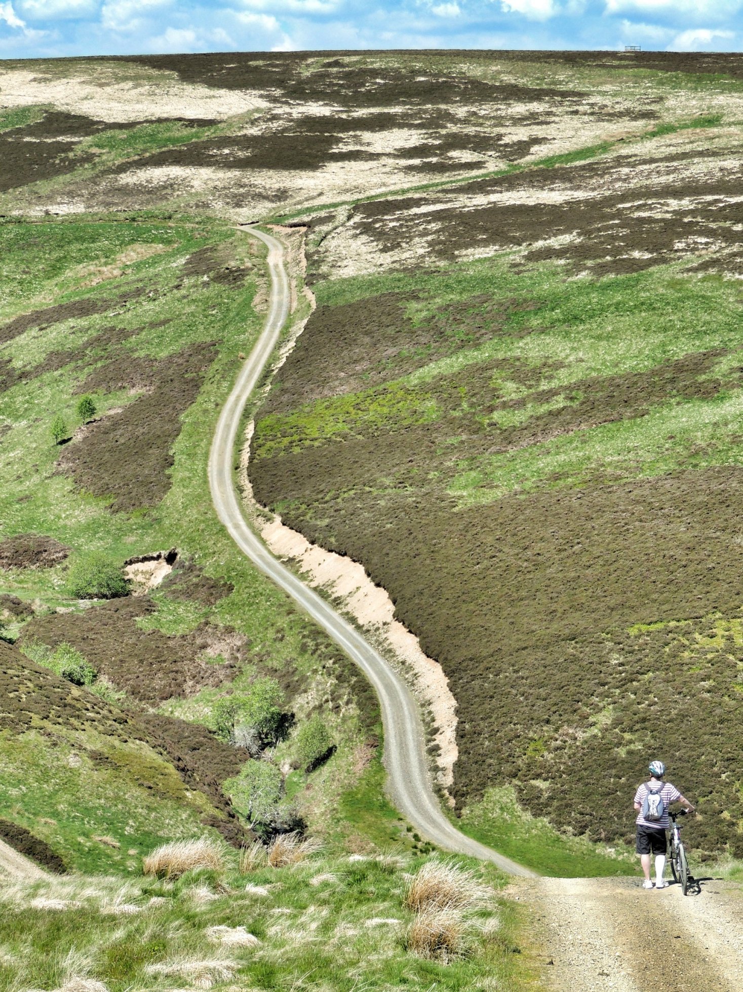
Daunting…
The wood itself is a lonely and stunted-looking plantation at the top of Mount Main at around 1700 ft. We paused alongside it for water (lots) and some energy-giving flapjack that Colette had made specially for the trip. We thought it was going to be all downhill from here, but around the next corner there was a sting in the tail: another really steep section to complete. I took a good run at it, but had to give up halfway up, and it was so steep and the surface so loose that there was no way I was getting started again. A final stint of pushing was therefore required.
View from the top
Once at the top, we had a great view northwards towards Edinburgh and beyond. We also could make out the road (B7007) from Innerleithen heading in the direction of home, and meeting up with that road was our next aim. We set off downhill, but soon discovered that the gradient was too steep to ride safely and we were promptly back on foot again, pushing downhill until the path was a little less steep. Pretty soon we were at the bottom of a gully, crossing two fords and approaching a fork in the road. The left fork headed in the general direction of the Innerleithen road, but my memory of the map (which I stupidly left at home) was to turn right. After heading left and doing about half a mile of going back uphill, I realized that we were going the wrong way and headed back for the alternative route. This was a good call, as not only was it the correct road, it was also much more fun, winding left and right, down into fords and back up again.
Eventually we reached a farm and could see the main road (B709) beyond. Pretty soon we had got through the farm and up to the road. We were exhausted by this stage – it was all much harder than we had expected, but the point was that we had actually done it. Our original intention was to go on to the B7007 Innerleithen road and turn right, heading north uphill towards home. But we just couldn’t face the thought of that climb, so instead we returned (very slowly) via Heriot and the A7.
That came to a total of 26.6 miles in a not very impressive sounding 4 hours – that is less than 7 mph overall! MapMyRide told us that was a total climb of 1341 ft, but I’ve since started using bikehike.co.uk, as it is generally thought to be more accurate for mapping routes, and that came out at 2041 ft, with gradients reaching 20%. I can believe that and I’m glad we did it, but we won’t be repeating it in a hurry!