
A little while ago, having now done the 100 miles in one day challenge, I was pondering what cycling challenge to try next. Well, one thing I’ve not really got into is cycle touring. Lots of people view Lands End to John O’Groats as the ultimate cycling challenge. I think that’s maybe a little too much for me to start with. Yes, it can be done at an easy pace, but that could take as much as 3 weeks and involve a lot of expensive accommodation, not to mention me being away from home for all that time. So I came up with something a bit more manageable that is still a significant challenge: to cycle to the four corners of Scotland.
By that I mean the Scottish mainland, the corners being Berwick upon Tweed (Southeast), Mull of Galloway (Southwest), Cape Wrath (Northwest) and John O’Groats (Northeast). That will be split up as follows:
1. Home to Berwick, just a single day trip to tick one off and get the ball rolling
2. Home to Mull of Galloway, a 3 day trip to get the touring feel, then if I survive that and enjoy it of course…
3. Home to Cape Wrath and John O’Groats, involving about 9 or 10 nights away and some challenging terrain (and probably weather as well!).
You might notice that these are not return journeys, i.e. I am only intending to cycle one way. To go there and back would cost twice as much, take twice as long, and going back home is never as much fun as the first half. That means persuading Colette to come and pick me up from my destinations!
So today was the first part of the challenge, heading to Berwick. I had concocted a plan where Colette would drive to Berwick soon after I got underway, and once there, she would have her own cycle trip (following National Cycle Route 1 to Holy Island and back seemed like a good idea), then we would meet up in Berwick and have something to eat before driving back.
My day started with me leaving the house at about 8.30am on a sunny August morning. Being a single day trip, I could get everything I needed into a small backpack so this was going to be the fastest of the trips, which I started by heading south down the A7.
The traffic was light and by and large courteous, with the exception of one random horn blaster (there’s always one), making it a pleasant ride down to Stow. I turned off there and headed for Lauder on the back road. I passed a local just before the steep 15% bit began and she wished me luck! This time I was focussing on slow and steady, which got me to the top without too much effort. I stopped for a quick drink and snack, and to take in the view. It was a bit hazy so not worth a photo. The haze was at least stopping the sun from being too strong, which was useful as I had forgot to put on any sunscreen before I left.
The downhill to Lauder was effortless, freewheeling at over 40mph at one point. Next it was right, through Lauder, then left at the other end. At this point I was following the route to Duns that I did earlier in the year so didn’t need to stop and check on directions yet.
Quick break at Westruther
At about 25 miles in, I got to the pretty village of Westruther, where I stopped at a bench beside an impressive floral display for more food and water (little and often seems to work well). Soon I was back on track, heading across moorland for a good number of miles before the road started going downhill. I joined the main road heading towards Duns and continued downhill at a good rate until reaching a sharp bend, where I took the tricky turnoff for Gavinton.
In Gavinton I found another bench, where I stopped and ate the first of my sandwiches. Colette meantime had texted to let me know that she had reached Spittal on the south side of Berwick and was about to head off for Holy Island. The plan was working sweetly so far.
After Gavinton, I was following a route criss-crossing through various minor roads on the south side of Duns. This involved an occasional stop to check the route using Viewranger on my phone, to reassure myself that I’d not taken any wrong turns. The roads undulated gently, then as I progressed, they seemed to get flatter and faster. I didn’t seem to have to go lower than my top 3 gears for a good number of miles. In fact, the profile shows that these roads were consistently very slightly downhill, explaining why it felt so easy. I was enjoying zooming along and tried to keep it going as long as possible, knowing that since my destination was not too far away now, I could safely tire myself out.
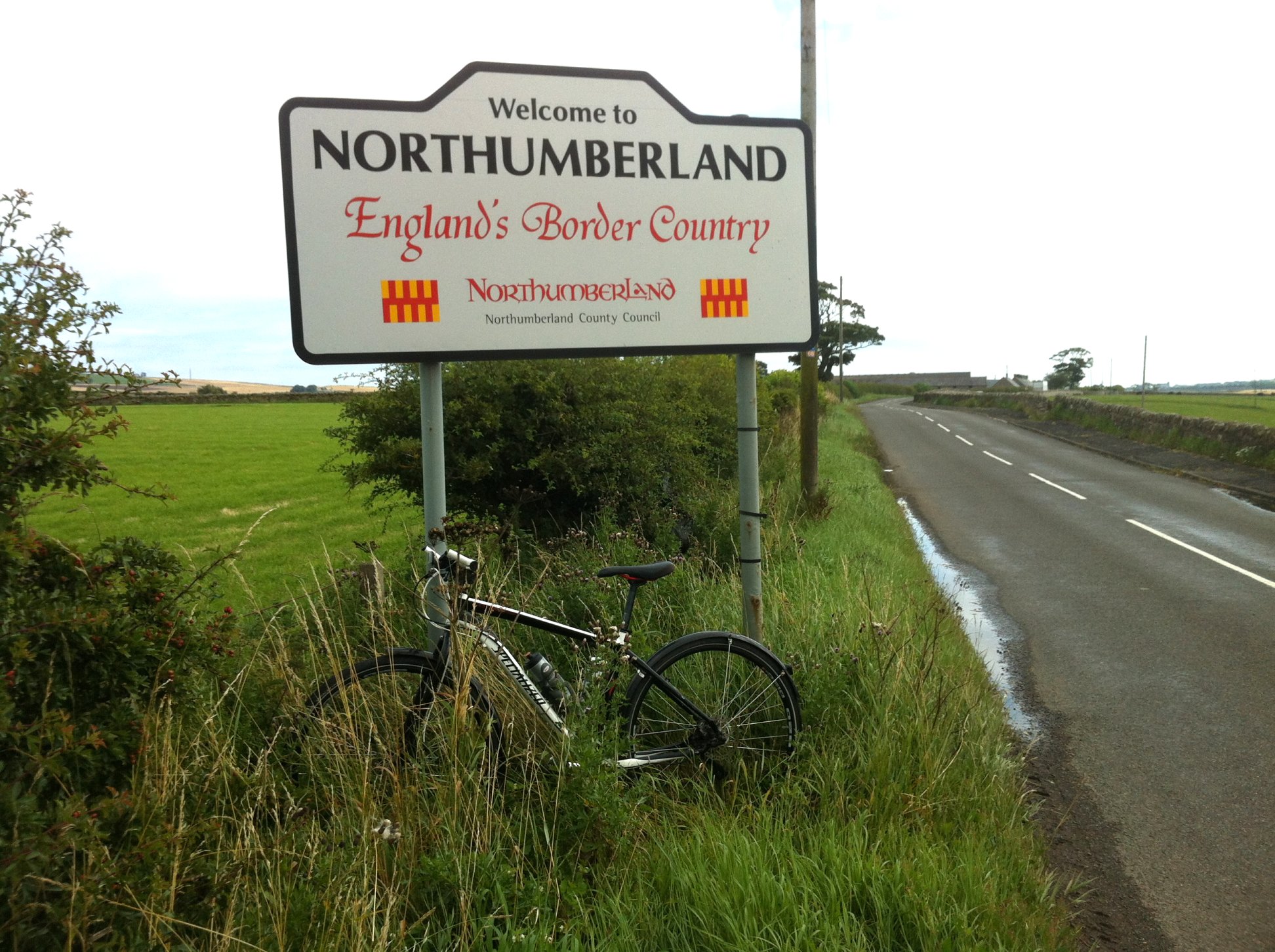
Made it all the way to England!
When I turned left onto Paxton Road, I knew that Berwick was not far away. The Tweed came into view on my right and then I came to a sign telling me that I was now in Northumberland. That was worth stopping for a photo.
At that point I also saw a text from Colette saying that the cycle path was awful – just a field. I hadn’t expected that, and now felt guilty for sending her off there without checking properly first. However, there was nothing I could do now but keep going on my way…
It wasn’t long before I came to the A1. Here I followed the blue route 1 signs that took me on a pavement alongside the dual carriageway, across the main road then along the other side before diverting away from the A1. The path at this point was overgrown with dog roses and other jaggy bushes which grabbed onto me as I passed, trying to pull me off the bike. Clearly nobody uses this path any more, but I wasn’t sure where the alternative was.
At the other end, I got onto a farm track that became a proper road as I approached the outskirts of Berwick. There was no sign saying “Berwick upon Tweed” on this road, otherwise I would have paused for a commemorative photo. I just carried on, joining up with the main road into town, which I followed into the centre in a line of traffic.
It was my intention to explore the town a little and get photos of the bike and/or me at various locations. I had even given some thought to cycling out to the actual Scotland-England border, time permitting.
To digress a little, it could be said that the Southeast corner is technically where the Scotland-England border crosses the coast. That is a couple of miles north of Berwick at Marshall Meadows. To get there would involve cycling up to A1 for a mile or so, turning right across the dual carriageway and going down to a caravan site. Then I would need to push the bike for a further half a mile or more through a field to reach the border, which might only be recognisable by use of GPS. I was still pondering the possibility of trying this while I was coming into town, although to my mind, Berwick being situated on the north bank of the Tweed is the natural, historic and symbolic SE corner of Scotland, seeing as the Tweed marks the actual border for so much of its length.
So, getting back to the point, I stopped in the middle of Berwick next to a bustling street market, to stop Strava and take some photos. When I looked at my phone though, I saw some texts from Colette saying that she was lost. I phoned her and she seemed very unsure of where she was, so I told her not to worry as she could always backtrack, and I was on my way to meet her.
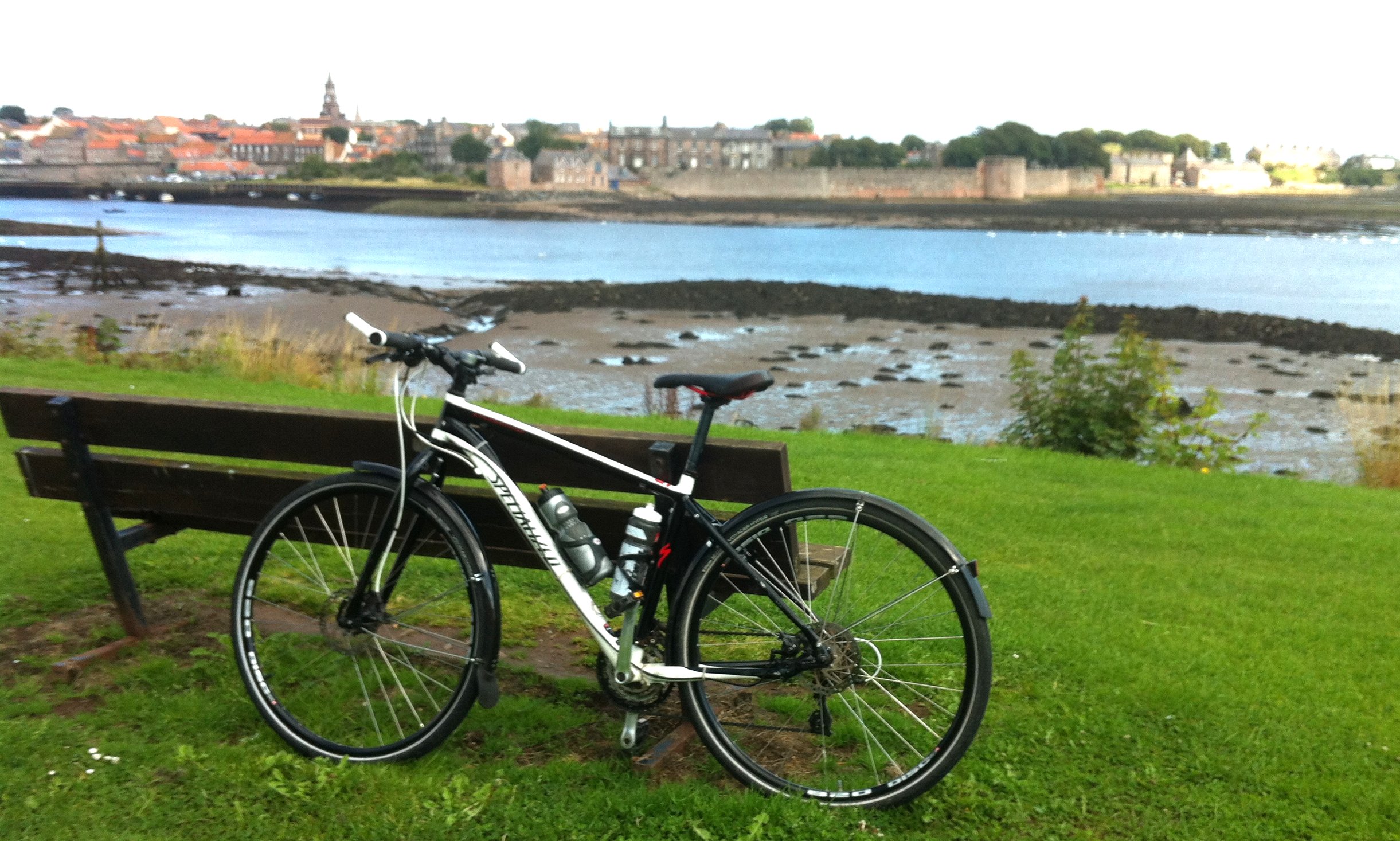
Very blurry photo of my bike looking over the Tweed to Berwick. Where is Colette when you need her?
The exploration of Berwick went by the wayside as I had more important things to do, so I got myself onto the old single track bridge and crossed over to the south side of the river. A little further on, I passed a great viewpoint looking back over the river and decided to stop for one quick photo to mark the end of part 1 of the 4 corners challenge before getting back to the search for my lost wife!
I had chanced onto route 1 again, so followed it into Spittal and out the other side, where it turned into a rough track. I stopped to call Colette again and by this time she had got herself to a place called Beal where she had found a cafe to stop and have a drink. She was feeling a bit better having done this, but she still didn’t know where she was. I couldn’t help, but luckily a passer by was able to explain where Beal was, and that she must have taken the wrong turn as she approached the causeway to Holy Island. Oh well, I had come this far, I was going to continue towards Beal and hopefully meet up with her.
Continuing down the track, it went from an acceptable potholed path to just simply a grassy field, with muddy ruts worn into the grass. It was incredible to think that this was actually a national cycle route, and the sparse signage had me questioning whether I’d taken a wrong turn somehow.
Luckily the field came to an end and route 1 continued along a minor road right at the coast, where many cars had parked for a day out by the seaside, and there was even an ice cream van. That was noted for the way back!
The route continued to vary in quality as it went, as well as crossing over the main east coast railway. It crossed back over the rail line at Goswick golf course but the barriers were closed when I arrived. This was a cue for me to get my other sandwich out, and I was nearly finished by the time the barriers opened again. I finished it off as I rode, spilling little bits of coleslaw onto the road as I went.
I stopped to check my phone for more texts (I just can’t hear them coming in when I’m riding) and found that Colette had worked it out and had now made her way onto the island. I was glad that she hadn’t had to give up before reaching her destination.
Crossing more rough ground, the sun was now beating down, I was being bombarded by clouds of tiny flies and my water supplies were just about exhaused. In fact, I might have been exhausted if I let myself be, but I had to keep going. When I finally reached the causeway, I found out that Colette was already on it, coming back across to the mainland. So I was able to have a wee rest till she arrived. What a relief it was to see her!
From her account, Holy Island was a bit of a let down, at least in terms of photo ops. It was also unbelievably busy so she was glad to get away. Maybe this is a place to investigate well away from English school holiday season.
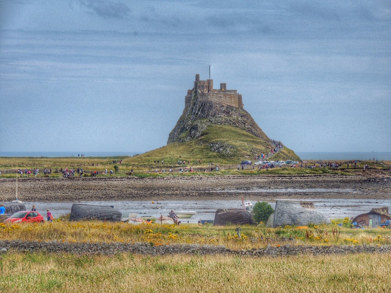
What Colette saw on the island… Lindisfarne Castle
As we rode away from the coast, we came across a signpost that was at the root of all Colette’s problems. The post clearly showed route 1 going right (towards Beal), whereas the pointer showing the extension of route 1 left onto Holy Island had been snapped off and was missing. Since I’d told Colette to follow route 1, she went off to Beal instead. Let’s hope that gets mended soon!
We now retraced our steps feeling hot and tired. At last we came to the ice cream van, where we had a 99 each, and I downed a can of diet Fanta in short order. A couple of miles later, we had reached the car, which we loaded with our bikes and headed back into Berwick.
Neither of us were up to anything more adventurous than MacDonalds, and while Colette was standing in the queue, I went to the toilets for a wash. I’m sure I got some funny looks when after my hands and arms, I washed my face, and then my hair. But it felt a lot better afterwards! I made sure to order a maxi size diet cola with my meal and took it in the car to help me rehydrate on the drive back home.
So that was part 1 of the challenge, amounting to about 51 miles of cycling, plus an unplanned 20 mile extension… and that was supposed to be the easy part!