
Recent coverage in the news of a particularly challenging cycling “sportive” brought my attention to Lowther Hill in the Scottish southern uplands. This cycle event for ultra-fit participants involves 100 miles of riding through hilly country, finishing with an ascent of Lowther Hill from Wanlockhead, Scotland’s highest village. At the top of the climb is a golf ball-like radar tracking station, which is why the road is tarmacked all the way to the top. I thought it would be fun to try the climb as part of a much less ambitous 40 mile loop.
The day started at the car park in Abington, about an hour’s drive from home. It was bright and sunny but a little chilly, so we got ourselves warmly wrapped up for the departure, heading towards the junction with the M74.
After a couple of roundabouts, we were clear of the roar of the motorway and onto a cycle path at the side of the old A74. We followed this for a short while, then turned left, heading away from the main road and into hilly farmland. The road followed the contours of the hillside in an arc, bringing us to the village of Crawfordjohn. We turned left there and made our way up through a valley into moorland. I used to regard this part of the world as bleak and desolate, but in the sunshine it all looked very scenic. I think cycling has allowed me to appreciate this kind of landscape much better. In addition, the road was mostly in good condition and very quiet, adding to our enjoyment.
Over the highest point, we began to descend towards Sanquhar, whereupon the moor gave way to enclosed fields once more, and trees reappeared. Then we stopped abruptly for a set of traffic lights at a T-junction with the A76. Here, we turned left and headed into the town of Sanquhar. Although far from the prettiest town in the world, it did appear to have its charms. As we cycled through, we were on the lookout for a decent-looking cafe and a bakers. Well, Colette was looking for the former and I was looking for the latter, where I thought we might be able to get something to supplement our picnic. We paused at the far end of the town, opposite the ruins of Sanquhar castle, having failed to spot the cafe. Colette reported having seen the baker, but I decided against doubling back as I was keen to press on.
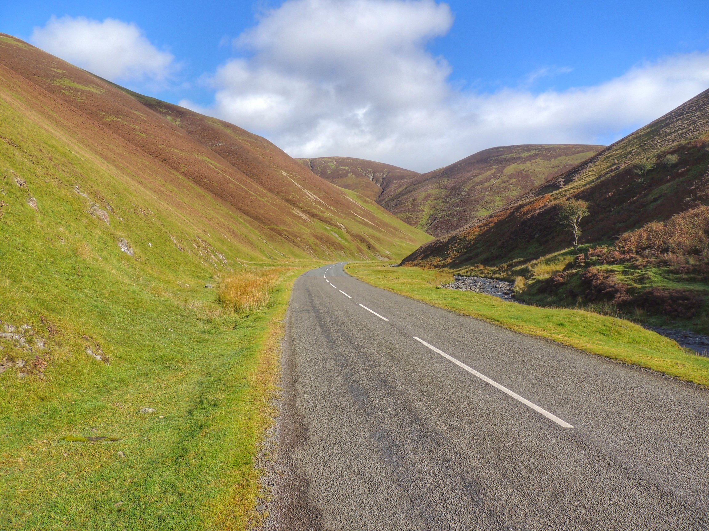
The A76 was intermittently quiet then busy, possibly something to do with the traffic lights further back. However, we didn’t have to stay on it for long, as we took the left turn at Mennock. Here was the start of the Mennock Pass, which leads up to Wanlockhead. The road to start was a little steep, then it levelled off for a while, running through a wood with a fast babbling stream alongside.
Before long, we came to a nicely-situated bench overlooking the burn. That looked like a good place to stop for lunch. It’s nice to have a proper seat for a picnic, so thanks to Granny Jean Scott (1927-2005), in whose memory the bench was placed there. The tuna sandwiches were good, but perhaps not quite enough fuel given the hard climb ahead. A bun or two from the bakers might have been a good idea after all.
The Mennock Pass
After lunch we set off again, following the road through an impressive valley with steeply-sided hills on either side. It reminded me a lot of the Granites near Innerleithen.
From this point, the gradient started to increase, but was still easily manageable for us at a gentle pace. There were plenty of stops to remove glove liners, neck warmers, etc., as the climb warmed us up, then finally at the top of a steep rise, we could see Wanlockhead below us in a dip.
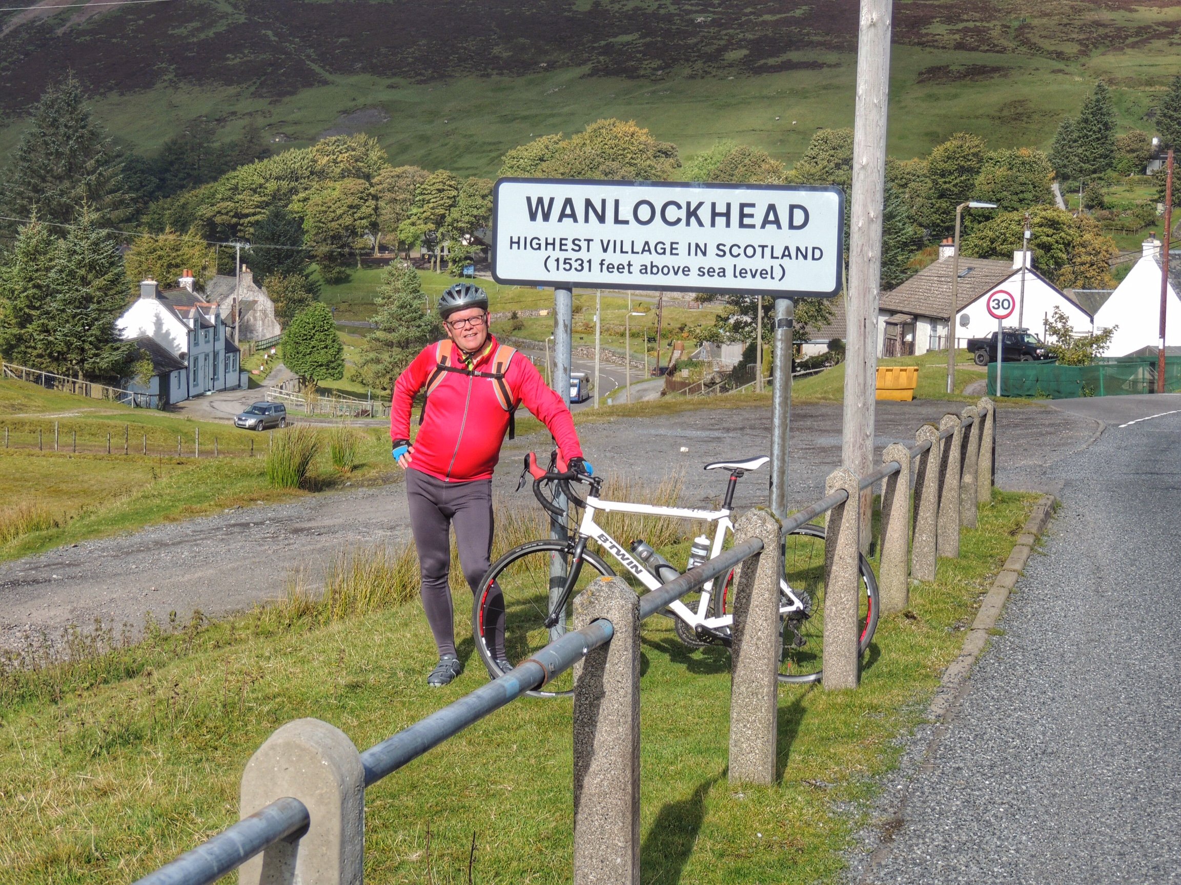
Made it to Wanlockhead, but there was more to come…
We stopped at the sign for some photos, then carried on through the village. The road climbed again for a while, then we came to the junction with the Lowther Hill road. It is signed as a private road and has a gate that may be closed and locked at any time. However, neither of these is any impediment to bike riders, so after checking with Colette that she really wanted to go ahead with this, off we went up Lowther Hill.
When it comes to climbing steep hills, it’s important to keep to your own pace. On the other hand, I wanted us to do the climb together, so whenever I got to the top of a steep bit, I stopped and waited for Colette to catch up. Stopping before the end of a steep bit is a no-no, as it’s hard to get started again!
The only way is up!
After the first steep, winding section, the road levelled off for a while before going steeply up again. Colette was progressing a bit slower than me, and I admit to feeling guilty about dragging her up the hill. However she was adamant that she wanted to do it, and she was definitely enjoying it. So that was great! Onwards and upwards then…
Wanlockhead in the distance, and a glimpse of the road that brought us up here.
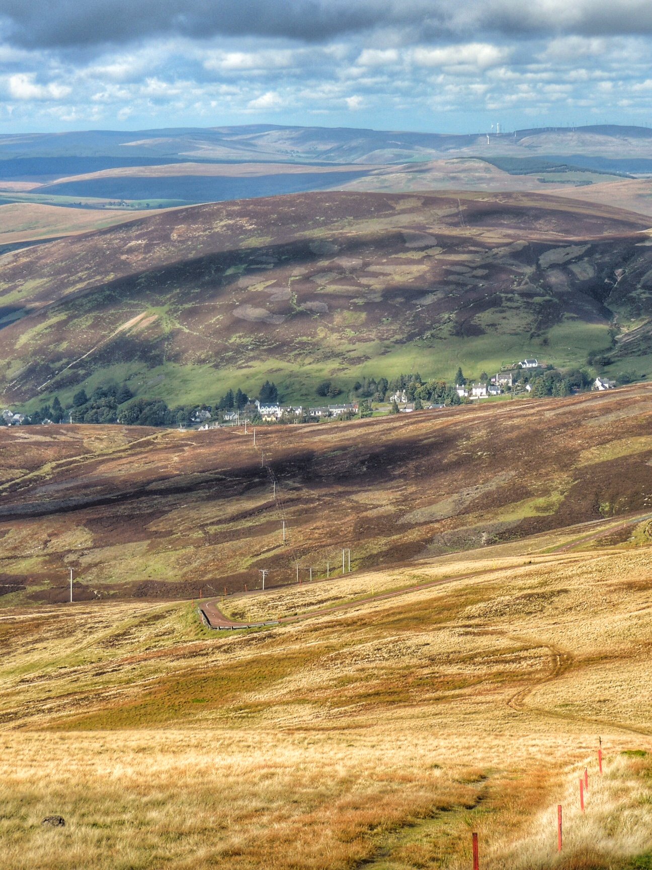
The rest of the climb followed this pattern, taking one section at a time. As we progressed, the view opened out and it was amazing how small and far away Wanlockhead looked below us.
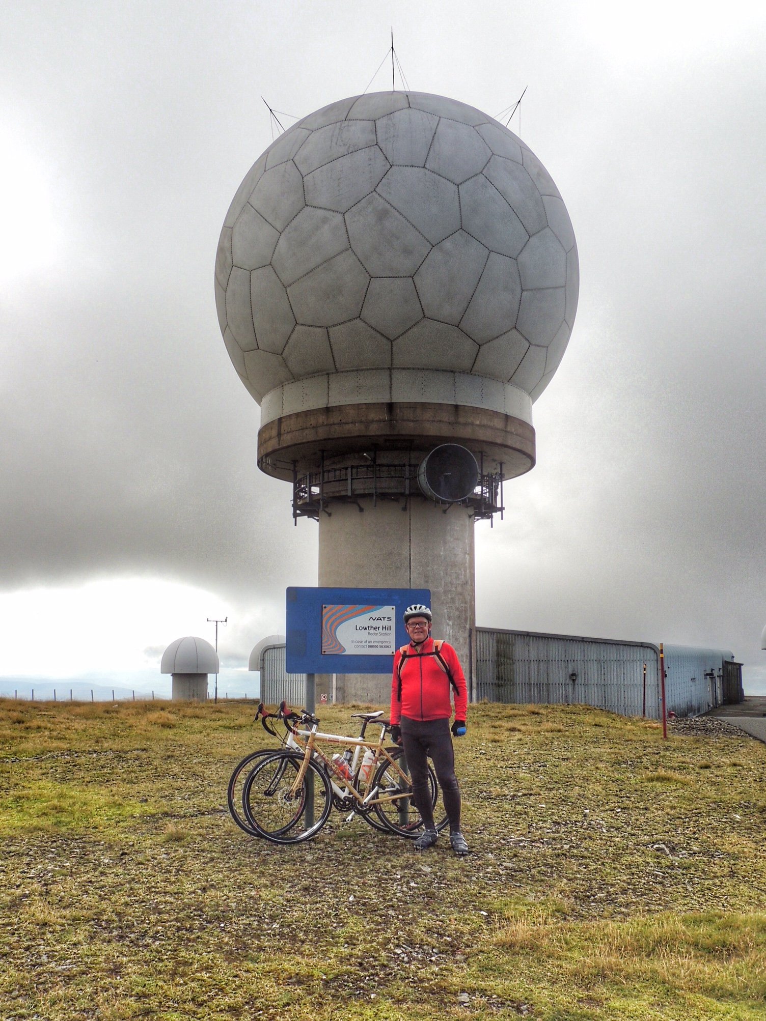
Success!
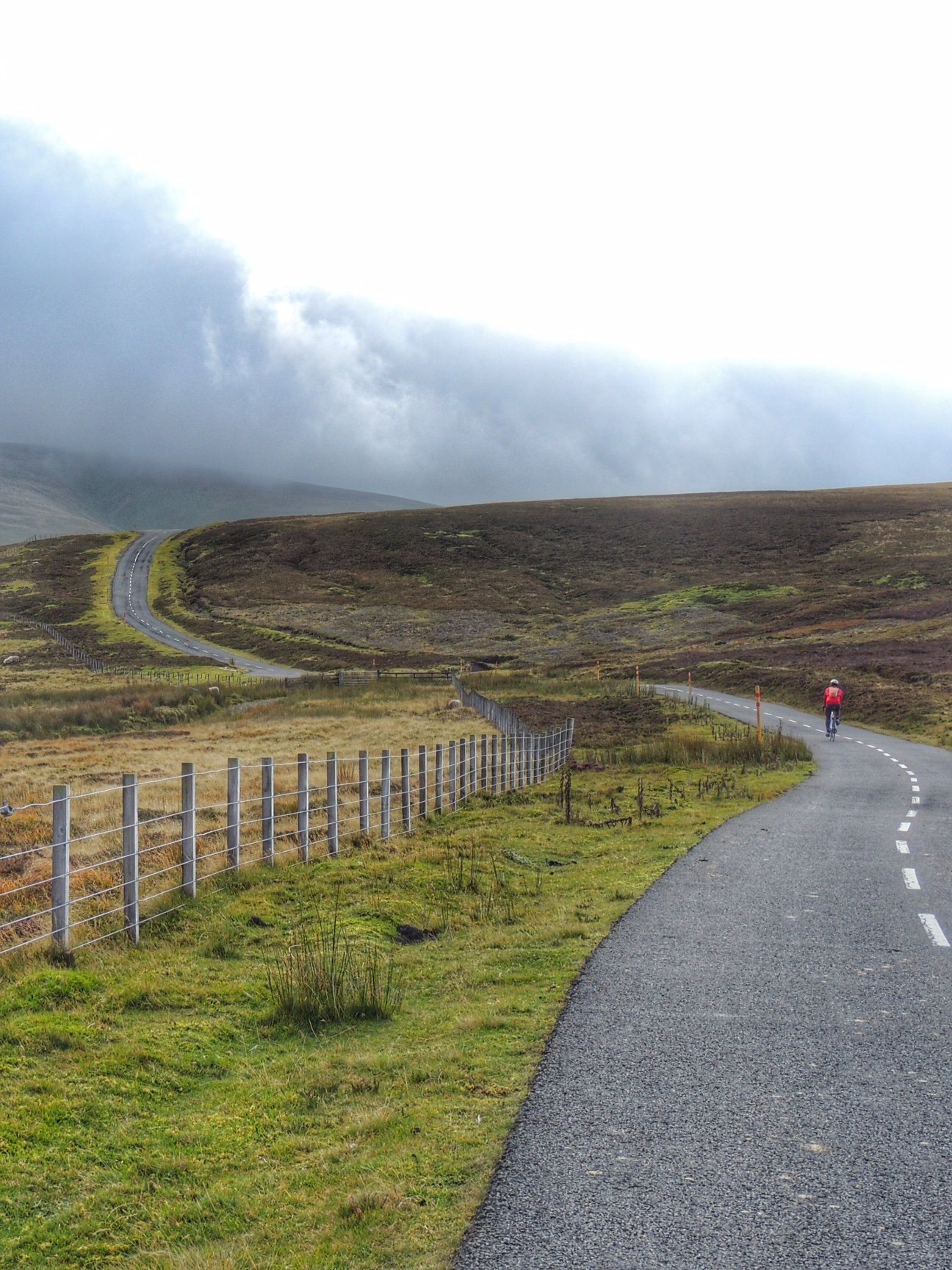
Finally we reached the top of the hill, where the golf ball was partly shrouded in mist for most of the time. Or to be more accurate, cloud level started right there at the summit. It was a bit chilly and there wasn’t anything to hang around for, so after taking a few photos, we hopped back on the bikes ready to head downhill again.
This was the part that really worried me: not the climb, but the descent. I was really hoping my brakes were good enough! As it happened, I had no problems, but I made sure to take it slow and brake heavily for the initial winding, steep drop, then eased off as the road got straighter and less vertical. Even with a stop halfway down to admire the view, it was amazing how quickly we got all the way to the bottom. The worst part was a drainage channel across the road right at the bottom which both of us managed to hit too quickly, getting some jarred bones but thankfully no punctures as a result.
Now, I had claimed that it would be downhill all the way after this, but a steep little hill still loomed ahead of us as we rejoined the road from Wanlockhead to Leadhills. Luckily, that didn’t go any further than it looked, and over the other side we were into a downhill. We couldn’t go very fast though, as the left side of the road here was an absolute bone shaker. It gradually improved by the time we reached Leadhills though.
The village of Leadhills looked old and quaint and characterful, which wasn’t what I was expecting from a defunct mining village. It actually has various tourist attractions, such as the mining museum and narrow gauge railway. However, it was out of season, so there was nothing to stop for and so we rode on through.
From there back to Abington the road was predominantly downhill, meaning we made good pace and by the time we got back to the car, our average speed was not too bad, considering the speed we went up the big hill! If you measure it from the start of Mennock Pass, the overall climb to the top of Lowther Hill was about 2000 feet, making it our biggest so far. Admittedly we are among the very slowest cyclists ever to do this climb, but I like to look at it this way: we’re fairly ambitious for cyclists of our limited ability!